Difference between revisions of "Cound Halt"
From SVR Wiki
(additional info and history) |
m (→See also: add links) |
||
| Line 22: | Line 22: | ||
==See also== | ==See also== | ||
| − | [[Maps# | + | *[[The Severn Valley Railway under GWR/BR ownership# Map of the Route and Nearby Railways | The Severn Valley Railway under GWR/BR ownership]] |
| + | *[[Maps#Map 1 - Shrewsbury to Hartlebury | Pre-1965 Map]] | ||
| + | *[[Shropshire Historic Environment Record]] | ||
==References== | ==References== | ||
<references /> | <references /> | ||
{{StationNavbox}} | {{StationNavbox}} | ||
Revision as of 15:28, 22 July 2019

Cound Halt in 1963. From the Sellick Collection.

An aerial view of Cound in 1936, looking towards Shrewsbury. The halt is located by the kink in the river at bottom right, by the group of buildings including the Riverside Inn. Image from Britain from Above
| Towards Hartlebury and Kidderminster | Towards Shrewsbury |
|---|---|
| Cressage | Berrington |
The village of Cound is situated approximately halfway between Cressage and Berrington, on the banks of the River Severn. Cound Halt opened on 4 August 1934, one of a number of halts opened by the GWRGreat Western Railway in the 1930s in a bid to attract more local custom. It consisted of a simple wooden platform with a small wooden shelter, although it was electrically lit.[1]
The approach to the halt included a sign giving information for fishermen, and it is probable that more fishermen than local inhabitants made use of the halt.[2]
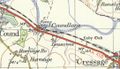
Historic Maps of Cound Halt
- 1961 map showing Cound Halt with Cressage station approximately 1.4 miles to the south east
1961

See also
- The Severn Valley Railway under GWR/BR ownership
- Pre-1965 Map
- Shropshire Historic Environment Record
References
- ↑ Mitchell & Smith (2007) figs. 106-108.
- ↑ Mitchell & Smith (2007) fig. 107.
| ||||||||||||||||||||