Difference between revisions of "National Cycle Route 45"
(additional info and history) |
(featured article) |
||
| Line 1: | Line 1: | ||
| + | __NOTOC__ | ||
[[File: Route_45_20150528.jpg|thumb|200px|right| National Cycle Route 45]] | [[File: Route_45_20150528.jpg|thumb|200px|right| National Cycle Route 45]] | ||
| − | '''National Cycle Route 45''' travels in sections from Chester to Salisbury, a total distance of 219 miles.<ref>Sustrans.org</ref> Part of the route follows the [[Severn Valley]] between the Ironbridge Gorge and Bewdley, utilising the former trackbed and crossing the present day railway twice. | + | '''National Cycle Route 45''', also known as the "Mercian Way", travels in sections from Chester to Salisbury, a total distance of 219 miles.<ref>Sustrans.org</ref> Part of the route follows the [[Severn Valley]] between the Ironbridge Gorge and Bewdley, utilising sections of the former trackbed and crossing the present day railway twice. |
| − | Route 45 crosses from the east bank of the [[River Severn]] to the west bank via Abraham Darby’s bridge at Ironbridge. From the site of the former [[Ironbridge|Ironbridge station]], now the main town car park, it then closely follows the disused trackbed southwards via [[Jackfield Halt]], [[Coalport]] and [[Linley]] to the edge of Bridgnorth Golf Club. From there the Route follows roads through the town, continuing up Hollybush Road where it passes under the | + | Route 45 crosses from the east bank of the [[River Severn]] to the west bank via Abraham Darby’s bridge at Ironbridge. From the site of the former [[Ironbridge|Ironbridge station]], now the main town car park, it then closely follows the disused trackbed southwards via [[Jackfield Halt]], [[Coalport]] and [[Linley]] to the edge of Bridgnorth Golf Club. From there the Route follows roads through the town, continuing up Hollybush Road where it passes under the [[Bridgnorth#Footbridge_outside_Bridgnorth_Station |footbridge outside Bridgnorth Station]] and crosses the former line between the station and [[Bridgnorth Tunnel]]. |
| − | South of Bridgnorth, the Route then follows the road through the villages of Eardington and Chelmarsh, returning to cross the railway at the [[Underbridge at Hampton Loade]]. From there it runs alongside the present day railway from [[Hampton Loade | Hampton Loade Station]] towards [[Country Park Halt]]. | + | South of Bridgnorth, the Route then follows the road through the villages of Eardington and Chelmarsh, returning to cross the railway at the [[Underbridge at Hampton Loade]]. From there it runs alongside the present-day railway from [[Hampton Loade | Hampton Loade Station]] towards [[Country Park Halt]]. |
| + | <gallery mode=packed heights=150px style="text-align:left"> | ||
| + | Crossing_13_20150528.jpg | Hampton Loade Station seen from the Cycle Route (right) | ||
| + | Mercian Way 20090817.jpg | This Mercian Way marker overlooks the railway | ||
| + | </gallery> | ||
This part of the Cycle Route was built by Shropshire County Council in [[Severn Valley Railway Timeline 2000-2009#2003 | 2003]]. The SVR Board initially decided to oppose its construction as it would be on the SVR's land and in close proximity to the line. However it transpired that the SVR's rejecting the cycle path could have adversely affected a number of other projects being put forward for European funding at the time, including [[The Engine House]]. After revised plans were drawn up including suitable fencing and landscaping of the cycle path to minimise its impact on the Railway, and following considerable discussion, the Board agreed to support the project.<ref>SVR News 146, "Boardroom Notes"</ref> Today the route is popular with both cyclists and walkers. | This part of the Cycle Route was built by Shropshire County Council in [[Severn Valley Railway Timeline 2000-2009#2003 | 2003]]. The SVR Board initially decided to oppose its construction as it would be on the SVR's land and in close proximity to the line. However it transpired that the SVR's rejecting the cycle path could have adversely affected a number of other projects being put forward for European funding at the time, including [[The Engine House]]. After revised plans were drawn up including suitable fencing and landscaping of the cycle path to minimise its impact on the Railway, and following considerable discussion, the Board agreed to support the project.<ref>SVR News 146, "Boardroom Notes"</ref> Today the route is popular with both cyclists and walkers. | ||
| − | Route 45 leaves the SVR a short distance before the Halt, turning away into the main area of the Country Park. However a footpath continues to the Halt itself. After passing through the Country Park, Route 45 crosses the railway again at [[Arley Station Bridge]], then enters the [[Wyre Forest]], where it follows the trackbed of the [[Wyre Forest Line]] towards [[Bewdley]]. | + | Route 45 leaves the SVR a short distance before the Halt, turning away into the main area of the Country Park. However a footpath continues to the Halt itself. There are a number of [[List of infrastructure | farm crossings]] between Hampton Loade and Country Park which also cross the Cycle Route. After passing through the Country Park, Route 45 crosses the railway again at [[Arley Station Bridge]], then enters the [[Wyre Forest]], where it joins and follows the trackbed of the former [[Wyre Forest Line]] towards [[Bewdley]]. |
| + | <gallery mode=packed heights=150px style="text-align:left"> | ||
| + | Cycle path through Wyre Forest - geograph.org.uk - 1149603.jpg | Road overbridge in the Wyre Forest | ||
| + | </gallery> | ||
| − | Between Bewdley and Stourport, Route 45 passes under the part of the [[Stourport Branch]] owned by the SVR via the road underbridge between Bewdley South junction and Mount Pleasant tunnel (item SVR022* in the [[Wyre Forest District Council Local Heritage List]]). | + | Between Bewdley and Stourport, Route 45 passes under the part of the [[Stourport Branch]] owned by the SVR via the road underbridge between Bewdley South junction and Mount Pleasant tunnel (item SVR022* in the [[Wyre Forest District Council Local Heritage List]]). |
| + | <gallery mode=packed heights=150px style="text-align:left"> | ||
| + | SVR022star.JPG | Bridge SVR022* on the Stourport Branch | ||
| + | </gallery> | ||
| − | + | East of [[Stourport]], Route 45 re-joins the former trackbed by the old railway bridge over the [[Staffordshire & Worcestershire Canal]]. From there it follows the former trackbed towards [[Hartlebury]] for approximately 1 mile before turning away towards the south at Charlton Lane. | |
<gallery mode=packed heights=150px style="text-align:left"> | <gallery mode=packed heights=150px style="text-align:left"> | ||
| − | + | Wilden_Top_Road_Overbridge_20201107.jpg|Route 45 passes under Wilden Top Road Overbridge | |
| − | + | Charlton_Lane_Overbridge_20201107.jpg|Route 45 leaves the former SVR at Charlton Lane Overbridge | |
| − | |||
| − | |||
</gallery> | </gallery> | ||
| + | |||
| + | ===Bewdley Bike Week=== | ||
| + | Bewdley Bike Week began in 2015 as part of the Big Bike Revival and National Bike Week.<ref>[https://www.kidderminstershuttle.co.uk/news/13309613.first-bewdley-bike-week-hailed-a-success/ Kiderminster Shuttle]</ref>. The SVR is regularly involved, offering a 'Rail and Ride' facility<ref>[https://www.facebook.com/bewdleybikeweek/posts/pfbid0oXJhJTwikXnn5MUT7eRe94xWbTMQL8K4mxWzz52FtyB2bb7eGxWFtoEARK4prJRGl?locale=en_GB Bewdley Bile Week on Facebook]</ref>. | ||
==See also== | ==See also== | ||
| − | [[From The Window]] | + | *[[From The Window]] |
| − | [[Hampton Loade | Hampton Loade Station]] | + | *[[Hampton Loade | Hampton Loade Station]] |
| − | [[Country Park Halt]] | + | *[[Country Park Halt]] |
| − | [[Farm crossing north of milepost 145]] | + | *[[Farm crossing north of milepost 145]] |
| − | [[Farm crossing near milepost 145]] | + | *[[Farm crossing near milepost 145]] |
==References== | ==References== | ||
| Line 33: | Line 45: | ||
==Links== | ==Links== | ||
*[https://www.sustrans.org.uk/find-a-route-on-the-national-cycle-network/route-45/ Route 45 on the Sustrans web site] | *[https://www.sustrans.org.uk/find-a-route-on-the-national-cycle-network/route-45/ Route 45 on the Sustrans web site] | ||
| + | [[Category:Featured articles]] | ||
Latest revision as of 15:11, 24 June 2024

National Cycle Route 45, also known as the "Mercian Way", travels in sections from Chester to Salisbury, a total distance of 219 miles.[1] Part of the route follows the Severn Valley between the Ironbridge Gorge and Bewdley, utilising sections of the former trackbed and crossing the present day railway twice.
Route 45 crosses from the east bank of the River Severn to the west bank via Abraham Darby’s bridge at Ironbridge. From the site of the former Ironbridge station, now the main town car park, it then closely follows the disused trackbed southwards via Jackfield Halt, Coalport and Linley to the edge of Bridgnorth Golf Club. From there the Route follows roads through the town, continuing up Hollybush Road where it passes under the footbridge outside Bridgnorth Station and crosses the former line between the station and Bridgnorth Tunnel.
South of Bridgnorth, the Route then follows the road through the villages of Eardington and Chelmarsh, returning to cross the railway at the Underbridge at Hampton Loade. From there it runs alongside the present-day railway from Hampton Loade Station towards Country Park Halt.
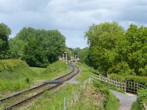
Hampton Loade Station seen from the Cycle Route (right)
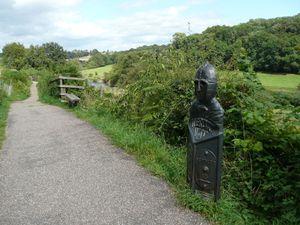
This Mercian Way marker overlooks the railway


This part of the Cycle Route was built by Shropshire County Council in 2003. The SVRSevern Valley Railway Board initially decided to oppose its construction as it would be on the SVRSevern Valley Railway's land and in close proximity to the line. However it transpired that the SVRSevern Valley Railway's rejecting the cycle path could have adversely affected a number of other projects being put forward for European funding at the time, including The Engine House. After revised plans were drawn up including suitable fencing and landscaping of the cycle path to minimise its impact on the Railway, and following considerable discussion, the Board agreed to support the project.[2] Today the route is popular with both cyclists and walkers.
Route 45 leaves the SVRSevern Valley Railway a short distance before the Halt, turning away into the main area of the Country Park. However a footpath continues to the Halt itself. There are a number of farm crossings between Hampton Loade and Country Park which also cross the Cycle Route. After passing through the Country Park, Route 45 crosses the railway again at Arley Station Bridge, then enters the Wyre Forest, where it joins and follows the trackbed of the former Wyre Forest Line towards Bewdley.
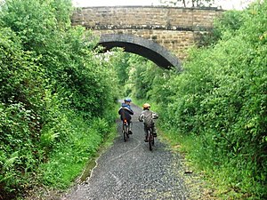
Road overbridge in the Wyre Forest

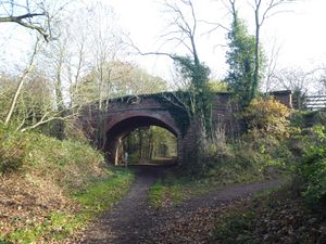
Between Bewdley and Stourport, Route 45 passes under the part of the Stourport Branch owned by the SVRSevern Valley Railway via the road underbridge between Bewdley South junction and Mount Pleasant tunnel (item SVR022* in the Wyre Forest District Council Local Heritage List).

Bridge SVR022* on the Stourport Branch

East of Stourport, Route 45 re-joins the former trackbed by the old railway bridge over the Staffordshire & Worcestershire Canal. From there it follows the former trackbed towards Hartlebury for approximately 1 mile before turning away towards the south at Charlton Lane.

Route 45 passes under Wilden Top Road Overbridge
Route 45 leaves the former SVRSevern Valley Railway at Charlton Lane Overbridge


Bewdley Bike Week
Bewdley Bike Week began in 2015 as part of the Big Bike Revival and National Bike Week.[3]. The SVRSevern Valley Railway is regularly involved, offering a 'Rail and Ride' facility[4].
See also
- From The Window
- Hampton Loade Station
- Country Park Halt
- Farm crossing north of milepost 145
- Farm crossing near milepost 145
References
- ↑ Sustrans.org
- ↑ SVRSevern Valley Railway News 146, "Boardroom Notes"
- ↑ Kiderminster Shuttle
- ↑ Bewdley Bile Week on Facebook