Difference between revisions of "Sand Pit siding at Buildwas"
From SVR Wiki
m (Typo) |
(Date when the siding opened) |
||
| Line 1: | Line 1: | ||
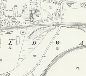
[[File:OS_Buildwas_1927.jpg|thumb|300px|right|1927 OS Map of Buildwas]] | [[File:OS_Buildwas_1927.jpg|thumb|300px|right|1927 OS Map of Buildwas]] | ||
| − | + | During the First World War a sand pit was opened directly opposite Buildwas Abbey, between [[Buildwas]] and [[Cressage]], a short distance west of the crossing on the Buildwas to Much Wenlock Road (now the A4169).<ref>[[Bibliography#Books|Vanns (1998)]] p. 28.</ref> The sand pit was served by a short siding on the Severn Valley Branch which can be seen on the extract from the OS Map of 1927. | |
Access to siding was controlled by a ground frame electrically released from Buildwas Station signal box.<ref>[https://www.s-r-s.org.uk/html/gws/S3034.htm Great Western Signal Box Register - Signalling Record Society]</ref> | Access to siding was controlled by a ground frame electrically released from Buildwas Station signal box.<ref>[https://www.s-r-s.org.uk/html/gws/S3034.htm Great Western Signal Box Register - Signalling Record Society]</ref> | ||
Latest revision as of 13:28, 9 May 2023
During the First World War a sand pit was opened directly opposite Buildwas Abbey, between Buildwas and Cressage, a short distance west of the crossing on the Buildwas to Much Wenlock Road (now the A4169).[1] The sand pit was served by a short siding on the Severn Valley Branch which can be seen on the extract from the OSOrdnance Survey Map of 1927.
Access to siding was controlled by a ground frame electrically released from Buildwas Station signal box.[2]
The area occupied by the siding has been restored to a green field site, although an active sand and gravel quarry is located on the opposite side of the Much Wenlock road, in the area between the former Severn Valley and Much Wenlock branches[3].
See also
- Private sidings connected to the Severn Valley Railway
- Pre-1963 map
- List of historical Signal Boxes and Ground Frames
