Difference between revisions of "Talk:Map"
(Created page with "The route of the Railway with links looks good & works very well. ~~~~") |
|||
| (7 intermediate revisions by 3 users not shown) | |||
| Line 1: | Line 1: | ||
The route of the Railway with links looks good & works very well. [[User:Sharpo|Sharpo]] ([[User talk:Sharpo|talk]]) 10:08, 15 January 2015 (UTC) | The route of the Railway with links looks good & works very well. [[User:Sharpo|Sharpo]] ([[User talk:Sharpo|talk]]) 10:08, 15 January 2015 (UTC) | ||
| + | |||
| + | I gave up on the template idea, that's just a table with embedded images and links, which ends up looking and behaving the same.<br> | ||
| + | At the moment, I can show the table with no borders, or I a can align it to the right, but not both at the same time.<br> | ||
| + | For some reason, aligning it to the right puts a 1 pixel border round every cell, which shows up as breaks in the red line.<br> | ||
| + | --[[User:Graham Phillips 110|Graham Phillips 110]] ([[User talk:Graham Phillips 110|talk]]) 10:14, 15 January 2015 (UTC) | ||
| + | |||
| + | A "straight" diagram of the SVR is always confusing, I think, as it is really a "U" shaped route. Gives the impression the mainline connection goes to the left at Kidder. I suppose the diagram could be made the shape of a reverse "J" but that might not fit the page so well, or may be more complicated? Just a suggestion! [[User:Sharpo|Sharpo]] ([[User talk:Sharpo|talk]]) 11:01, 15 January 2015 (UTC) | ||
| + | |||
| + | If at first you don't succeed, cheat.<br> | ||
| + | It is now a 1x1 table with all the icons and links in the single cell, separated by line breaks. It seems to work.<br> | ||
| + | I've labelled it as a schematic map, I'll still create an accurate geographic imagemap map as well, but I need a suitable map to base it on first.<br> | ||
| + | --[[User:Graham Phillips 110|Graham Phillips 110]] ([[User talk:Graham Phillips 110|talk]]) 12:52, 15 January 2015 (UTC) | ||
| + | |||
| + | Had a go at drawing the route of the Railway to scale, copied from a map. 3 major towns shown, also river, railway & most roads (but not the country lanes) | ||
| + | |||
| + | <imagemap> | ||
| + | File:Svr-line.jpg | ||
| + | rect 35 2 135 25 [[Bridgnorth | Bridgnorth]] | ||
| + | rect 240 545 350 570 [[Bewdley | Bewdley]] | ||
| + | rect 380 500 525 530 [[Kidderminster | Kidderminster]] | ||
| + | </imagemap> | ||
| + | |||
| + | |||
| + | It's far from perfect but is less overpowering than copying a map with too much detail on. Is it worth trying to develop it further by adding smaller villages & marking the stations? [[User:Sharpo|Sharpo]] ([[User talk:Sharpo|talk]]) 22:47, 15 January 2015 (UTC) | ||
| + | |||
| + | That's a lot better than the OS map I used. I've turned it in to an imagemap with links.<br> | ||
| + | There's a very basic map on the timetable brochure. [http://www.svr.co.uk/pdf/brochures/Timetable%20Preview%202015.pdf]<br> | ||
| + | There's a better one on the "From the window" leaflet, [http://www.svr.co.uk/pdf/brochures/FROM%20THE%20WINDOW%202014.pdf] I wonder if we could get permission to use it and have all three maps.<br> | ||
| + | --[[User:Graham Phillips 110|Graham Phillips 110]] ([[User talk:Graham Phillips 110|talk]]) 00:11, 16 January 2015 (UTC) | ||
| + | |||
| + | If you think it will be useful to develop it further, I can add stations & their names etc. but if anybody else has the skill & time to draw a better one - I won't mind. [[User:Sharpo|Sharpo]] ([[User talk:Sharpo|talk]]) 09:43, 16 January 2015 (UTC) | ||
| + | |||
| + | I really like the map on the front page - it worked out even better than I expected! I also have to praise Sharpo's mapmaking abilities. For the "From the window" leaflet, do you mean the map that covers several pages? I wonder if there might be an original version of that all in one piece, although the problem there is that it would be a rather large image. --[[User:Danny252|Danny252]] ([[User talk:Danny252|talk]]) 10:49, 16 January 2015 (UTC) | ||
| + | |||
| + | Yes, I was going to try to reproduce it more or less as it is with a link at the top and bottom of each page to the next page.<br> | ||
| + | I've emailed the Marketing & Communications Manager to ask permission to use the original image file. I've also asked for permission to use the SVR logo.<br> | ||
| + | --[[User:Graham Phillips 110|Graham Phillips 110]] ([[User talk:Graham Phillips 110|talk]]) 11:20, 16 January 2015 (UTC) | ||
Latest revision as of 11:20, 16 January 2015
The route of the Railway with links looks good & works very well. Sharpo (talk) 10:08, 15 January 2015 (UTC)
I gave up on the template idea, that's just a table with embedded images and links, which ends up looking and behaving the same.
At the moment, I can show the table with no borders, or I a can align it to the right, but not both at the same time.
For some reason, aligning it to the right puts a 1 pixel border round every cell, which shows up as breaks in the red line.
--Graham Phillips 110 (talk) 10:14, 15 January 2015 (UTC)
A "straight" diagram of the SVRSevern Valley Railway is always confusing, I think, as it is really a "U" shaped route. Gives the impression the mainline connection goes to the left at Kidder. I suppose the diagram could be made the shape of a reverse "J" but that might not fit the page so well, or may be more complicated? Just a suggestion! Sharpo (talk) 11:01, 15 January 2015 (UTC)
If at first you don't succeed, cheat.
It is now a 1x1 table with all the icons and links in the single cell, separated by line breaks. It seems to work.
I've labelled it as a schematic map, I'll still create an accurate geographic imagemap map as well, but I need a suitable map to base it on first.
--Graham Phillips 110 (talk) 12:52, 15 January 2015 (UTC)
Had a go at drawing the route of the Railway to scale, copied from a map. 3 major towns shown, also river, railway & most roads (but not the country lanes)
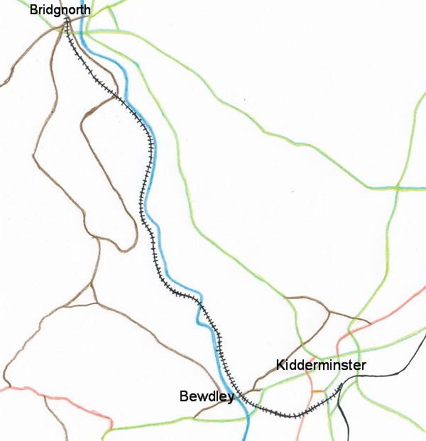

It's far from perfect but is less overpowering than copying a map with too much detail on. Is it worth trying to develop it further by adding smaller villages & marking the stations? Sharpo (talk) 22:47, 15 January 2015 (UTC)
That's a lot better than the OSOrdnance Survey map I used. I've turned it in to an imagemap with links.
There's a very basic map on the timetable brochure. [1]
There's a better one on the "From the window" leaflet, [2] I wonder if we could get permission to use it and have all three maps.
--Graham Phillips 110 (talk) 00:11, 16 January 2015 (UTC)
If you think it will be useful to develop it further, I can add stations & their names etc. but if anybody else has the skill & time to draw a better one - I won't mind. Sharpo (talk) 09:43, 16 January 2015 (UTC)
I really like the map on the front page - it worked out even better than I expected! I also have to praise Sharpo's mapmaking abilities. For the "From the window" leaflet, do you mean the map that covers several pages? I wonder if there might be an original version of that all in one piece, although the problem there is that it would be a rather large image. --Danny252 (talk) 10:49, 16 January 2015 (UTC)
Yes, I was going to try to reproduce it more or less as it is with a link at the top and bottom of each page to the next page.
I've emailed the Marketing & Communications Manager to ask permission to use the original image file. I've also asked for permission to use the SVRSevern Valley Railway logo.
--Graham Phillips 110 (talk) 11:20, 16 January 2015 (UTC)