Difference between revisions of "Foot crossing off Northwood Lane"
From SVR Wiki
m (Add footpath info) |
(add details) |
||
| Line 1: | Line 1: | ||
[[File: Northwood_Lane_Crossing_20150528.jpg |thumb|300px|right| Foot crossing off Northwood Lane]] | [[File: Northwood_Lane_Crossing_20150528.jpg |thumb|300px|right| Foot crossing off Northwood Lane]] | ||
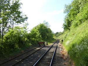
| − | The photo shows the location of a public right of way which crosses the SVR between Northwood Lane (to the west of the line) and Grey Green Lane, | + | The photo shows the location of a public right of way which crosses the SVR between Northwood Lane (to the west of the line) and Grey Green Lane, Wribbenhall (to the east). The tracks on the left of the picture are the former [[Tenbury Branch]] of the Tenbury and Bewdley Railway, now used as a siding by the SVR. |
| + | |||
| + | The right of way is shown on the [https://gis.worcestershire.gov.uk/website/Countryside/ Worcestershire CC Public Rights Of Way map], marked as PRoW 542(B) and 550(C). | ||
==See also== | ==See also== | ||
| Line 6: | Line 8: | ||
[[List of infrastructure]]<br> | [[List of infrastructure]]<br> | ||
[[Accommodation bridge off Northwood Lane| Towards Bridgnorth]] | [[Accommodation bridge off Northwood Lane| Towards Bridgnorth]] | ||
| + | |||
| + | ==Links== | ||
| + | *[https://www.worcestershire.gov.uk/council-services/environment/countryside-and-leisure/public-rights-way Worcestershire CC Public Rights Of Way] | ||
Latest revision as of 14:16, 22 February 2024
The photo shows the location of a public right of way which crosses the SVRSevern Valley Railway between Northwood Lane (to the west of the line) and Grey Green Lane, Wribbenhall (to the east). The tracks on the left of the picture are the former Tenbury Branch of the Tenbury and Bewdley Railway, now used as a siding by the SVRSevern Valley Railway.
The right of way is shown on the Worcestershire CC Public Rights Of Way map, marked as PRoW 542(B) and 550(C).
See also
Towards Kidderminster
List of infrastructure
Towards Bridgnorth
