File:OS LMR 1965.jpg
From SVR Wiki
Size of this preview: 351 × 599 pixels. Other resolutions: 140 × 240 pixels | 401 × 684 pixels.
Original file (401 × 684 pixels, file size: 113 KB, MIME type: image/jpeg)
Summary
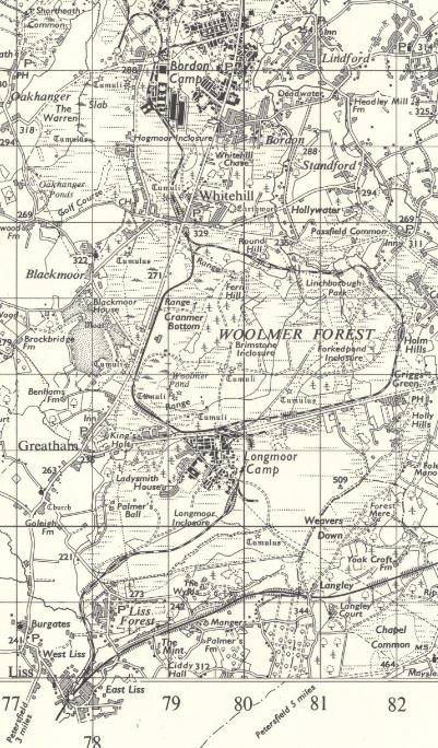
Extract from OSOrdnance Survey 1 in to 1 mile map Sheet 169 – Aldershot, Publication date: Revised: 1956 to 1964, Published: ca. 1965, showing the extent of the Longmoor Military Railway.
Licencing
This image is derived from an original Ordnance Survey Map held on the National Library of Scotland Map Images Website.
Reproduced with the permission of the National Library of Scotland under the terms of the Creative Commons Attribution-NonCommercial-ShareAlike (CC-BY-NC-SA) licence.
File history
Click on a date/time to view the file as it appeared at that time.
| Date/Time | Thumbnail | Dimensions | User | Comment | |
|---|---|---|---|---|---|
| current | 14:51, 14 May 2021 | | 401 × 684 (113 KB) | Robin (talk | contribs) | Extract from OS 1 in to 1 mile map Sheet 169 – Aldershot, Publication date: Revised: 1956 to 1964, Published: ca. 1965, showing the extent of the Longmoor Military Railway. |
- You cannot overwrite this file.
File usage
The following page links to this file: