File:Washout at Victoria Bridge - geograph.org.uk - 552055.jpg
From SVR Wiki

Size of this preview: 450 × 600 pixels. Other resolutions: 180 × 240 pixels | 480 × 640 pixels.
Original file (480 × 640 pixels, file size: 105 KB, MIME type: image/jpeg)
Summary
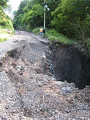
| Description |
English: Washout at Victoria Bridge. This gaping hole at the eastern end of Victoria Bridge was the result of the heavy storms of 19th June. At this point the track had been removed to allow repairs to commence and the picture was taken during a visit to temporarily disconnect the signalling equipment.
The hole has now been repaired although damage elsewhere means that it will be several months yet before trains are again running through here. In the meantime the Severn Valley Railway continues to operate between Kidderminster and Bewdley. |
| Date | |
| Source | From geograph.org.uk |
| Author | David Stowell |
| Attribution (required by the licence) | David Stowell / Washout at Victoria Bridge / |
| Camera location | | View this and other nearby images on: OpenStreetMap |
|---|
_heading:135.00&language=en-gb)
| Object location | | View this and other nearby images on: OpenStreetMap |
|---|
_heading:135.00&language=en-gb)
Licensing

|
This image was taken from the Geograph project collection. See this photograph's page on the Geograph website for the photographer's contact details. The copyright on this image is owned by David Stowell and is licensed for reuse under the Creative Commons Attribution-ShareAlike 2.0 license.
|
This file is licensed under the Creative Commons Attribution-Share Alike 2.0 Generic licence.
Attribution: David Stowell
- You are free:
- to share – to copy, distribute and transmit the work
- to remix – to adapt the work
- Under the following conditions:
- attribution – You must give appropriate credit, provide a link to the licence, and indicate if changes were made. You may do so in any reasonable manner, but not in any way that suggests the licensor endorses you or your use.
- share alike – If you remix, transform, or build upon the material, you must distribute your contributions under the same or compatible licence as the original.
File history
Click on a date/time to view the file as it appeared at that time.
| Date/Time | Thumbnail | Dimensions | User | Comment | |
|---|---|---|---|---|---|
| current | 04:48, 6 February 2011 | | 480 × 640 (105 KB) | GeographBot | == {{int:filedesc}} == {{Information |description={{en|1=Washout at Victoria Bridge This gaping hole at the eastern end of Victoria Bridge was the result of the heavy storms of 19th June. At this point the track had been removed to allow repairs to comme |
File usage
The following 3 pages link to this file: