File:Shrewsbury (Coleham) Locomotive Depot 2082798 239fd19b.jpg
From SVR Wiki

Size of this preview: 800 × 414 pixels. Other resolutions: 320 × 166 pixels | 1,024 × 530 pixels.
Original file (1,024 × 530 pixels, file size: 246 KB, MIME type: image/jpeg)
Summary
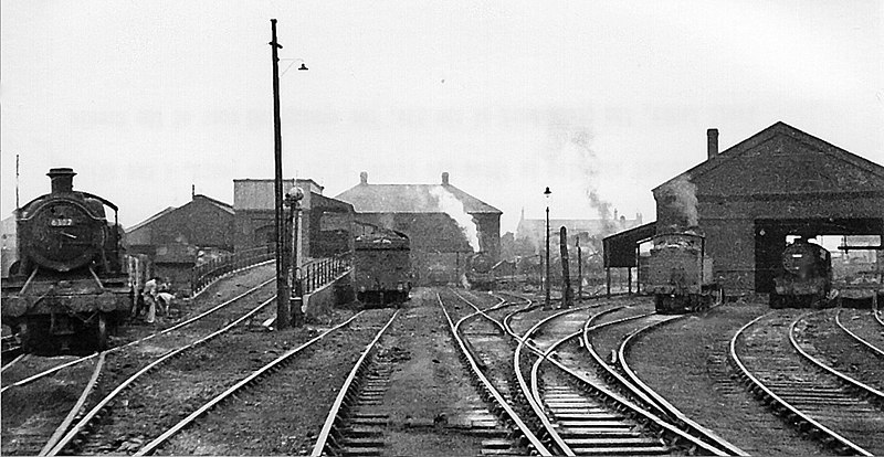
| Description |
English: Shrewsbury (Coleham) Locomotive Depot. View SE of two adjoining Depots of the ex-Great Western (left) and ex-London & North Western (right), which were situated beside the junction of the Severn Valley line (to Bridgnorth, Bewdley etc., closed 2/12/63) with the Shrewsbury - Hereford main line (GW & LNW Joint). They provided motive power for all the local and many of the main-line passenger and freight traffic in the area - except for the moribund Shropshire & Montgomeryshire Railway, which passed just to the east of the Depots as it entered Shrewsbury Abbey Station. In 1950, shortly after this photograph, the combined Depots (coded 84G in the Wolverhampton District of the BR Western Region) had an allocation of 124 locomotives, comprising:- 38 4-6-0s (19 GW, 19 LMS), 4 2-6-0s (all GW), 23 2-8-0s (2 GW, 16 LMS, 5 ex-WD), 5 0-8-0s (all LMS), 25 0-6-0s (7 GW, 18 LMS), 7 2-6-2Ts (3 GW, 4 LMS), 6 0-6-2Ts (5 GW, 1 LMS), 14 0-6-0Ts (12 GW, 2 LMS) and 2 0-4-0Ts (both LMS). There were a remarkable number of ancient engines in the LMS section - one of which (probably ex-LNW 0-6-2T No. 58904) can be seen on the right. The Depot closed to steam on 6/11/67, but was utilised for Diesel locomotive until 1972. |
| Date | |
| Source | From geograph.org.uk |
| Author | Ben Brooksbank |
| Permission (Reusing this file) |
Creative Commons Attribution Share-alike license 2.0 |
| Camera location | | View this and other nearby images on: OpenStreetMap |
|---|
_Locomotive_Depot_2082798_239fd19b.jpg¶ms=052.703255_N_-002.742139_E_globe:Earth_type:camera_heading:135.00&language=en-gb)
Licensing

|
This image was taken from the Geograph project collection. See this photograph's page on the Geograph website for the photographer's contact details. The copyright on this image is owned by Ben Brooksbank and is licensed for reuse under the Creative Commons Attribution-ShareAlike 2.0 license.
|
This file is licensed under the Creative Commons Attribution-Share Alike 2.0 Generic licence.
Attribution: Ben Brooksbank
- You are free:
- to share – to copy, distribute and transmit the work
- to remix – to adapt the work
- Under the following conditions:
- attribution – You must give appropriate credit, provide a link to the licence, and indicate if changes were made. You may do so in any reasonable manner, but not in any way that suggests the licensor endorses you or your use.
- share alike – If you remix, transform, or build upon the material, you must distribute your contributions under the same or compatible licence as the original.
File history
Click on a date/time to view the file as it appeared at that time.
| Date/Time | Thumbnail | Dimensions | User | Comment | |
|---|---|---|---|---|---|
| current | 20:34, 10 September 2017 | | 1,024 × 530 (246 KB) | Geograph Update Bot | Higher-resolution version from Geograph. |
File usage
The following page links to this file:
_Locomotive_Depot_2082798_239fd19b.jpg)
_Locomotive_Depot_2082798_239fd19b.jpg)
_Locomotive_Depot_2082798_239fd19b.jpg&action=edit&redlink=1)
_Locomotive_Depot_2082798_239fd19b.jpg)
_Locomotive_Depot_2082798_239fd19b.jpg)
_Locomotive_Depot_2082798_239fd19b.jpg&printable=yes)
_Locomotive_Depot_2082798_239fd19b.jpg&action=info)
_Locomotive_Depot_2082798_239fd19b.jpg&mobileaction=toggle_view_mobile)