File:Severn Valley Railway Bridge by Devils Spittleful Nature Reserve - geograph.org.uk - 664790.jpg
From SVR Wiki

Size of this preview: 450 × 600 pixels. Other resolutions: 180 × 240 pixels | 480 × 640 pixels.
Original file (480 × 640 pixels, file size: 163 KB, MIME type: image/jpeg)
Summary
| Description |
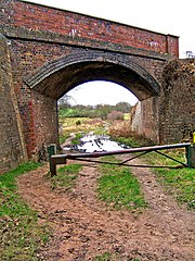
English: Severn Valley Railway Bridge by Devils Spittleful Nature Reserve The railway bridge is situated on the boundary of the Devils Spittleful Nature Reserve. It carries the preserved steam line, the Severn Valley Railway. Underneath is the bridleway which goes to the A456 Bewdley Road, ending opposite the public car park for visitors to Blackstone Rock. |
| Date | |
| Source | From geograph.org.uk |
| Author | P L Chadwick |
| Attribution (required by the licence) | P L Chadwick / Severn Valley Railway Bridge by Devils Spittleful Nature Reserve / |
| Camera location | | View this and other nearby images on: OpenStreetMap |
|---|
_heading:225.00&language=en-gb)
| Object location | | View this and other nearby images on: OpenStreetMap |
|---|
_heading:225.00&language=en-gb)
Licensing

|
This image was taken from the Geograph project collection. See this photograph's page on the Geograph website for the photographer's contact details. The copyright on this image is owned by P L Chadwick and is licensed for reuse under the Creative Commons Attribution-ShareAlike 2.0 license.
|
This file is licensed under the Creative Commons Attribution-Share Alike 2.0 Generic licence.
Attribution: P L Chadwick
- You are free:
- to share – to copy, distribute and transmit the work
- to remix – to adapt the work
- Under the following conditions:
- attribution – You must give appropriate credit, provide a link to the licence, and indicate if changes were made. You may do so in any reasonable manner, but not in any way that suggests the licensor endorses you or your use.
- share alike – If you remix, transform, or build upon the material, you must distribute your contributions under the same or compatible licence as the original.
File history
Click on a date/time to view the file as it appeared at that time.
| Date/Time | Thumbnail | Dimensions | User | Comment | |
|---|---|---|---|---|---|
| current | 19:36, 7 February 2011 | | 480 × 640 (163 KB) | GeographBot | == {{int:filedesc}} == {{Information |description={{en|1=Severn Valley Railway Bridge by Devils Spittleful Nature Reserve The railway bridge is situated on the boundary of the Devils Spittleful Nature Reserve. It carries the preserved steam line, the Sev |
File usage
The following 2 pages link to this file: