Summerfield Siding

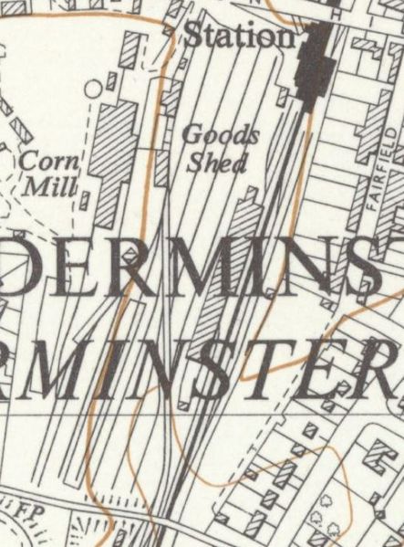
The map extract (right) shows the layout of the top yard in 1938 with the Station at the top and Kidderminster Footbridge ("the Wooden Bridge") at the bottom. The private sidings for J.P.Harvey's corn mill can be seen on the left, [note 1] with the map appearing to show that they were separated from the rest of the yard by a fence. In 1943 two additional sidings were added in the area marked "310 1.624". One was a third siding for Harveys adjacent to the two shown on the map, and the other next to it was the Summerfield Siding. Although less detail is shown than on the earlier 25in map, the position of Summerfield Siding can be made out on the 1955 OSOrdnance Survey Map extract below. The security fence around the siding starts just under the letter 'R' next to J.P. Harvey's Corn Mill. Immediately to its left is the third siding for Harvey's built at the same time, a short distance from their two existing sidings.
OSOrdnance Survey Map of 1955

The Royal Ordnance Factory at Summerfield
No positive confirmation has been found on the ownership or use of the Summerfield Siding. However by 1941 the Ministry of Supply was building two new ammunition factories at Hayes in Middlesex and Summerfield, both operated by ICI's Metal Group.[2] It therefore appears probable from the name, date of construction and additional security fencing, that the siding was associated with that factory.
The Royal Ordnance Factory at Summerfield was on the southern outskirts of Kidderminster and around 2½ miles from the railway sidings. During World War II it manufactured explosives and filled projectiles and such factories drew in workers, many of which were women, from across the country. Two hostels were used for the Summerfield workers. One was the Butts Lane Royal Ordnance Factory Workers’ Hostel in Stone, located on private farmland around two miles east of the factory. The site is recorded under the Worcestershire Historic Environment Record.[3] During Wartime, open-topped buses were seen on Chester Road taking workers to the ICI factory.[4] It is likely workers from these hostels were among those bussed in.
After arms production, Summerfield was used as a Ministry of Supply store until 1951. It became Summerfield Research Station, a development and production site for solid rocket motors.
See also
Notes
- ↑ The map is a composite of two OSOrdnance Survey 25in maps, both revised and published circa 1938. It is not clear if the slight discontinuity in the sidings at the boundary of the map is simply due to printing differences or if some change in the layout of Harvey's sidings had taken place around that time.
References
- ↑ Turley (2005) p. 15., The Goods Yard
- ↑ ICI Metals Division on Graces Guide
- ↑ Midland Archaeological Services website (Retrieved 16 April 2024)
- ↑ Turley (2005) p. 5., The Wooden Bridge