Stourport Triangle
From SVR Wiki

The "Stourport Triangle" (also known as the "Bewdley Triangle") is the name given to the small area of land between the Kidderminster and Stourport lines as they diverge to the southeast of Bewdley. The ground in the area of the triangle was excavated to rail level in 1986 to provide filling for the Bewdley Bypass[1].
Current use
- Currently the remains of the Stourport Branch, the sidings which have been added since its closure and the ground around them are used for the storage of goods wagons and Permanent Way materials.
- On certain Gala days a Class 108 DMU shuttle service is operated between the Triangle, Bewdley and the short remaining length of former Tenbury Branch track immediately north of Bewdley to recreate the feel of Bewdley as a country junction station.
- In 2015, Rail Safety Solutions (RSS) entered an agreement with the SVRSevern Valley Railway to lease the Stourport Branch.[2] A small section of relaid track can be seen on the site, along with a hoarding bearing the logos of RSS, Auctus Training Solutions and the SVRSevern Valley Railway.
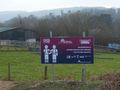
Poster at the Stourport Triangle in 2017
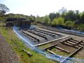
Examples of track work


Other proposals
From time to time proposals have been made to make use of this site.
- In 1973 a report was put forward suggesting siting a loco running shed there[3].
- In 1979 plans were drawn up for a three road carriage shed[4].
- The triangle was also planned to be the location of the SVRSevern Valley Railway’s turntable, acquired in 1980 but later installed at Kidderminster.
See also
List of rolling stock at the Stourport triangle
References
- ↑ Marshall (1989), p93
- ↑ SVRSevern Valley Railway News 192, "General Manager's Notes", Nick Ralls
- ↑ SVRSevern Valley Railway News 29
- ↑ SVRSevern Valley Railway News 50
Links
The Stourport Triangle on Google Earth