Difference between revisions of "Stourport Branch"
(update) |
(update) |
||
| Line 8: | Line 8: | ||
The SVR owns the track bed of the Stourport Branch from Bewdley through Mount Pleasant Tunnel to a point 302 yards beyond its southern portal, a short way north of Burlish Halt. The [[Severn Valley Railway Timeline 1970-1979#1973 | 1973 Light Railway Order]] allowed the SVR to operate over this section, although it has never been used for public services. The first ¾ mile was re-laid in 1975 for filming of [[The Seven-Per-Cent Solution]] to take place. Part of this short length of track is now used as a siding. | The SVR owns the track bed of the Stourport Branch from Bewdley through Mount Pleasant Tunnel to a point 302 yards beyond its southern portal, a short way north of Burlish Halt. The [[Severn Valley Railway Timeline 1970-1979#1973 | 1973 Light Railway Order]] allowed the SVR to operate over this section, although it has never been used for public services. The first ¾ mile was re-laid in 1975 for filming of [[The Seven-Per-Cent Solution]] to take place. Part of this short length of track is now used as a siding. | ||
| − | In 2015, Rail Safety Solutions (RSS) entered an agreement with the SVR to lease the branch as far as Mount Pleasant tunnel, for the purposes of training Network Rail apprentices in track laying and maintenance. In exchange, the SVR will gain ongoing training for its own staff, as well as use of the relaid track for occasional train services.<ref>SVR News 192, "General Manager's Notes", Nick Ralls</ref> {{As of|2016| | + | In 2015, Rail Safety Solutions (RSS) entered an agreement with the SVR to lease the branch as far as Mount Pleasant tunnel, for the purposes of training Network Rail apprentices in track laying and maintenance. In exchange, the SVR will gain ongoing training for its own staff, as well as use of the relaid track for occasional train services.<ref>SVR News 192, "General Manager's Notes", Nick Ralls</ref> {{As of|2016|11}} no track laying or similar work has taken place. |
Travelling from Bewdley, there are two underbridges on the branch before Mount Pleasant Tunnel is reached. Both are included in the [[Wyre Forest District Council Local Heritage List]]. The first (item SVR023*) is an Occupation Underbridge connecting fields on each side of the line. The second (item SVR022*) is a large stone and brick arched bridge with a 30 ft span and 28 ft high, lying on the publicly accessible track from the Bewdley Bypass to the farm near Safari Park curve and also to the [[Devil's Spittleful (Rifle Range) Bridge]] leading to the [[Rifle Range Halt | Devil's Spittleful & Rifle Range heathland]]. | Travelling from Bewdley, there are two underbridges on the branch before Mount Pleasant Tunnel is reached. Both are included in the [[Wyre Forest District Council Local Heritage List]]. The first (item SVR023*) is an Occupation Underbridge connecting fields on each side of the line. The second (item SVR022*) is a large stone and brick arched bridge with a 30 ft span and 28 ft high, lying on the publicly accessible track from the Bewdley Bypass to the farm near Safari Park curve and also to the [[Devil's Spittleful (Rifle Range) Bridge]] leading to the [[Rifle Range Halt | Devil's Spittleful & Rifle Range heathland]]. | ||
Revision as of 06:31, 19 November 2016

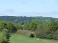
This was the route of the original Severn Valley line dating from 1862, connecting Bewdley and stations to the north with the main line at Hartlebury to the south. The Kidderminster to Bewdley link used by the present day SVRSevern Valley Railway opened in 1878. The area between the two lines is commonly referred to as the Stourport Triangle or Bewdley Triangle.
In the picture, the original path of the Severn Valley Railway is the line curving away to the right. A set of points allows entry to the sidings in the triangle, added by the SVRSevern Valley Railway during preservation.
There was an intermediate halt on the branch between Bewdley and Stourport, just on the Stourport side of Mount Pleasant Tunnel at Burlish.
The SVRSevern Valley Railway owns the track bed of the Stourport Branch from Bewdley through Mount Pleasant Tunnel to a point 302 yards beyond its southern portal, a short way north of Burlish Halt. The 1973 Light Railway Order allowed the SVRSevern Valley Railway to operate over this section, although it has never been used for public services. The first ¾ mile was re-laid in 1975 for filming of The Seven-Per-Cent Solution to take place. Part of this short length of track is now used as a siding.
In 2015, Rail Safety Solutions (RSS) entered an agreement with the SVRSevern Valley Railway to lease the branch as far as Mount Pleasant tunnel, for the purposes of training Network Rail apprentices in track laying and maintenance. In exchange, the SVRSevern Valley Railway will gain ongoing training for its own staff, as well as use of the relaid track for occasional train services.[1] As of November 2016[update] no track laying or similar work has taken place.
Travelling from Bewdley, there are two underbridges on the branch before Mount Pleasant Tunnel is reached. Both are included in the Wyre Forest District Council Local Heritage List. The first (item SVR023*) is an Occupation Underbridge connecting fields on each side of the line. The second (item SVR022*) is a large stone and brick arched bridge with a 30 ft span and 28 ft high, lying on the publicly accessible track from the Bewdley Bypass to the farm near Safari Park curve and also to the Devil's Spittleful (Rifle Range) Bridge leading to the Devil's Spittleful & Rifle Range heathland.
SVR023*
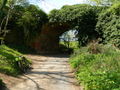
SVR022*


See also
References
- ↑ SVRSevern Valley Railway News 192, "General Manager's Notes", Nick Ralls