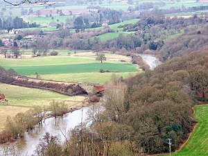
River Severn
The Severn is the longest river in the UK at around 220 miles, rising at Plynlimon in the Cambrian Mountains of mid-Wales and flowing into the sea via the Bristol Chanel[1].
The lower reaches of the Severn are relatively recent in geological terms. The Upper Severn used to flow into a large lake surrounding what is now Shrewsbury; this lake in turn drained into the Trent Basin. When the lake began to melt at the end of the last Ice Age, around 25,000 years ago, the original exit was blocked, probably by ice. The rising melt-water forced a new path through the ridge above Ironbridge, creating what is now the Ironbridge Gorge and the new course of the Lower Severn to the Bristol Channel[2].
The railway towns of Shrewsbury and Worcester are both situated on the river, so it was natural that a railway intended to link the two would follow the course of the Severn Valley. At the southern end the Severn Valley Railway began north of Hartlebury, around 2 miles east of the river. It rapidly approached the river at Stourport and from there it hugged the east bank, coming within a few yards at Folly Point, before crossing the river for the only time at Victoria Bridge. Thereafter the railway closely followed the west bank of the Severn past Bridgnorth, and through the Ironbridge Gorge. Once onto the flatter ground beyond Berrington the railway maintained a straighter course towards Shrewsbury while the river meandered, but even then they were rarely more than a mile apart.
References
- ↑ Wikipedia
- ↑ Marshall (1989), p2
