Difference between revisions of "Knowlesands Sidings"
(add photo) |
m (add links) |
||
| Line 25: | Line 25: | ||
==See also== | ==See also== | ||
| − | [[Maps# | + | *[[Private sidings connected to the Severn Valley Railway]] |
| − | [[List of signal boxes | List of | + | *[[Maps#Schematic maps of the pre-closure SVR | Pre-1963 map]] |
| + | *[[List of signal boxes#List of historical Signal Boxes and Ground Frames | List of historical Signal Boxes and Ground Frames]] | ||
==References== | ==References== | ||
[[Bibliography#Books | Mitchell and Smith (2007)]], Illustration XII<br> | [[Bibliography#Books | Mitchell and Smith (2007)]], Illustration XII<br> | ||
[[Bibliography#Books |Vanns (1998)]], p57 | [[Bibliography#Books |Vanns (1998)]], p57 | ||
Revision as of 17:37, 30 November 2018

Knowlesands Sidings were situated around ¾ mile south of Bridgnorth station, midway between Knowlesands Tunnel and Oldbury Viaduct. They took the form of a loop to the west of the line, capable of holding 35 standard wagons plus engine and brake van. The sidings served Knowlesands Brick Works, and opened in 1922. Their location is shown on the extract from the Ordnance Survey Map, 1937-1961 series.
The site of the Brick Works is now occupied by the Severn Valley Industrial Estate which can be seen from the railway, although no trace remains of the sidings.
Knowlesands Sidings ground frames
Access to the sidings was controlled by ground frames at either end of the loop. These were unlocked by a key in the end of the Electric Train Staff. The working timetable of 1922 gave instructions that if the 8.15am Shrewsbury to Kidderminster goods was to stop at the sidings, the Bridgnorth signalman should telephone his colleague at Highley, and vice versa for the 8.40am Hartlebury to Shrewsbury goods.
A name plate from Knowlesands North ground frame is on display in Kidderminster Railway Museum.
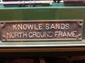
Knowlsands North Ground Frame name plate

Historic maps of Knowlesands Sidings
- 1884 map showing the location before the brickworks or sidings were built.
- 1903 map showing 'Knowlesands Brick Works' unconnected to the railway.
- 1927 map showing 'Bridnorth Brick Works' and the sidings.
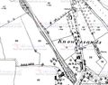
1884
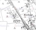
1903
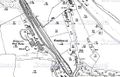
1927


See also
- Private sidings connected to the Severn Valley Railway
- Pre-1963 map
- List of historical Signal Boxes and Ground Frames
References
Mitchell and Smith (2007), Illustration XII
Vanns (1998), p57