Difference between revisions of "J.H.Smith"
From SVR Wiki
(Created page with "thumb|300px|right|Map showing the location of J.P.Harvey's Corn Mill J.H.Smith is listed in the RCH 1938 Handbook of Stations as...") |
(add link) |
||
| (2 intermediate revisions by one other user not shown) | |||
| Line 1: | Line 1: | ||
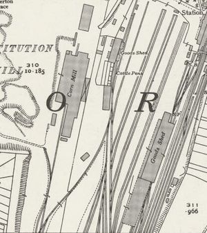
[[File:Kidderminster Goods Yard map 1938.jpg|thumb|300px|right|Map showing the location of J.P.Harvey's Corn Mill]] | [[File:Kidderminster Goods Yard map 1938.jpg|thumb|300px|right|Map showing the location of J.P.Harvey's Corn Mill]] | ||
| − | J.H.Smith is listed in the RCH 1938 Handbook of Stations as having a business at Kidderminster accessed via [[J.P.Harvey's Corn Mill | J.P.Harvey's siding]]. | + | J.H.Smith is listed in the RCH 1938 Handbook of Stations as having a business at Kidderminster accessed via [[J.P.Harvey's Corn Mill | J.P.Harvey's siding]]. |
| − | + | ||
| + | The 1938 OS map shows a short siding leading off from Harvey's siding towards what appears to be surface workings, raising the possibility that Smith's may have been extracting sand or gravel. The business of 'Jn Herbt Smith' of 101 Comberton Hill was that of a builder<ref>[https://drive.google.com/file/d/1KKjFjKSzAa9_XQnL2HeRNwZ-QsaPkqvn/view Kelly's Directory of Worcestershire 1936] (Retrieved 4 May 2021)</ref><ref>[https://drive.google.com/file/d/1BH3sPghx0qvnwzGwgqIDoolVZiKnNblx/view Midland Counties of England Trade Directory 1948-49]</ref>. | ||
==See also== | ==See also== | ||
| Line 8: | Line 9: | ||
==References== | ==References== | ||
| − | Railway Clearing House ''Handbook of Stations including Junctions, sidings, | + | Railway Clearing House ''Handbook of Stations including Junctions, sidings, Collieries, Works &C.'' 1938 |
| + | <references/> | ||
==Links== | ==Links== | ||
[https://maps.nls.uk/view/1208987921938 1:25000 Ordnance Survey map of Kidderminster on the National Library of Scotland web site] | [https://maps.nls.uk/view/1208987921938 1:25000 Ordnance Survey map of Kidderminster on the National Library of Scotland web site] | ||
Latest revision as of 19:44, 16 May 2021
J.H.Smith is listed in the RCHRailway Clearing House 1938 Handbook of Stations as having a business at Kidderminster accessed via J.P.Harvey's siding.
The 1938 OSOrdnance Survey map shows a short siding leading off from Harvey's siding towards what appears to be surface workings, raising the possibility that Smith's may have been extracting sand or gravel. The business of 'Jn Herbt Smith' of 101 Comberton Hill was that of a builder[1][2].
See also
Private sidings connected to the Severn Valley Railway
J.P.Harvey's Corn Mill
References
Railway Clearing House Handbook of Stations including Junctions, sidings, Collieries, Works &C. 1938
- ↑ Kelly's Directory of Worcestershire 1936 (Retrieved 4 May 2021)
- ↑ Midland Counties of England Trade Directory 1948-49
Links
1:25000 Ordnance Survey map of Kidderminster on the National Library of Scotland web site
