Difference between revisions of "H. Whitehouse's Sand Siding"
m (typo) |
(add pictures etc) |
||
| Line 1: | Line 1: | ||
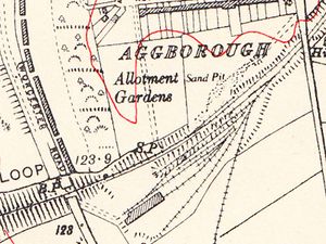
| + | [[File:OS_Kidderminster_1938.jpg|thumb|300px|right|OS map showing the Sand Siding north of the Loop Line, opposite [[Kidderminster Shed]].]] | ||
H. Whitehouse’s Sand Siding was situated on the [[Kidderminster Loop Line]] at milepost 135¾, between Kidderminster Junction and the [[Ground Frames at Foley Park | Foley Park sugar beet siding]], on the falling gradient of 1 in 112 towards Bewdley. Access to the siding was controlled by a ground frame which was locked by the Electric Train Token for the Kidderminster Junction – Bewdley South section. | H. Whitehouse’s Sand Siding was situated on the [[Kidderminster Loop Line]] at milepost 135¾, between Kidderminster Junction and the [[Ground Frames at Foley Park | Foley Park sugar beet siding]], on the falling gradient of 1 in 112 towards Bewdley. Access to the siding was controlled by a ground frame which was locked by the Electric Train Token for the Kidderminster Junction – Bewdley South section. | ||
The siding could hold up to 12 wagons, and was facing to trains from the direction of Bewdley. Traffic from the siding was worked by the Kidderminster shunting engine, which would draw wagons out onto the main line and then propel them back towards Kidderminster Junction. Such propelling movements could only be carried out in clear weather and at reduced speed, with a guard in the leading brake van providing hand signals to the driver where necessary. | The siding could hold up to 12 wagons, and was facing to trains from the direction of Bewdley. Traffic from the siding was worked by the Kidderminster shunting engine, which would draw wagons out onto the main line and then propel them back towards Kidderminster Junction. Such propelling movements could only be carried out in clear weather and at reduced speed, with a guard in the leading brake van providing hand signals to the driver where necessary. | ||
| + | |||
| + | The OS Map of 1938 shows the area between [[Hoo Road Bridge]] (right) and [[Worcester Road Bridge]] (left). [[Kidderminster Shed]] is located south of the loop line with the sand siding and the sand pit that it served to the north of the line. | ||
==See also== | ==See also== | ||
Revision as of 16:15, 20 August 2018
H. Whitehouse’s Sand Siding was situated on the Kidderminster Loop Line at milepost 135¾, between Kidderminster Junction and the Foley Park sugar beet siding, on the falling gradient of 1 in 112 towards Bewdley. Access to the siding was controlled by a ground frame which was locked by the Electric Train Token for the Kidderminster Junction – Bewdley South section.
The siding could hold up to 12 wagons, and was facing to trains from the direction of Bewdley. Traffic from the siding was worked by the Kidderminster shunting engine, which would draw wagons out onto the main line and then propel them back towards Kidderminster Junction. Such propelling movements could only be carried out in clear weather and at reduced speed, with a guard in the leading brake van providing hand signals to the driver where necessary.
The OSOrdnance Survey Map of 1938 shows the area between Hoo Road Bridge (right) and Worcester Road Bridge (left). Kidderminster Shed is located south of the loop line with the sand siding and the sand pit that it served to the north of the line.
See also
List of historical Signal Boxes and Ground Frames
References
Instructions for Train Working to Whitehouse’s Siding. Service Timetable for February 1943, reproduced in Turley (2005), p134.
