Difference between revisions of "Foley Park"
m (add picture) |
m (add links and picture) |
||
| Line 2: | Line 2: | ||
* [[Foley Park Halt]], open between 1905 and 1970. | * [[Foley Park Halt]], open between 1905 and 1970. | ||
| − | * [[Foley Park sidings]], serving the British Sugar Corporation and Smethwick Drop Forgings. | + | * [[Foley Park sidings]], serving the British Sugar Corporation, [[Thomas Vale & Sons]] and [[Smethwick Drop Forgings Ltd. Siding|Smethwick Drop Forgings]]. |
* [[Ground Frames at Foley Park]], covering several ground frames related to the sidings and the BR/SVR boundary. | * [[Ground Frames at Foley Park]], covering several ground frames related to the sidings and the BR/SVR boundary. | ||
* [[Gravel Pit at Foley Park]], connected by a siding in 1901 and shown on the 1902 Ordnance Survey map. | * [[Gravel Pit at Foley Park]], connected by a siding in 1901 and shown on the 1902 Ordnance Survey map. | ||
| Line 8: | Line 8: | ||
The area includes the [[Safari Park#Possible_future_station|site of a possible future station]] serving the [[Safari Park]] and developments of the Sugar works site, and mooted from time-to-time for an extension of mainline services. | The area includes the [[Safari Park#Possible_future_station|site of a possible future station]] serving the [[Safari Park]] and developments of the Sugar works site, and mooted from time-to-time for an extension of mainline services. | ||
| − | It also includes the site of the proposed [[Wagon Review Group|Wagon shed]]. In winter 2019-20 the opportunity was taken to install a set of points at Foley Park for future use with a siding or carriage shed. | + | It also includes the site of the proposed [[Wagon Review Group|Wagon shed]]. In winter 2019-20 the opportunity was taken to install a set of points at Foley Park for future use with a siding or carriage shed. The points will be controlled by a [[Ground Frames at Foley Park|ground frame]] which was previously installed at Kidderminster. |
<gallery mode=packed heights=200px style="text-align:left"> | <gallery mode=packed heights=200px style="text-align:left"> | ||
Foley_Park_Points_20200912.jpg|The new points at Foley Park. The [[Underbridge off Lisle Avenue]] is just beyond the points with [[Falling Sands Viaduct]] in the distance. | Foley_Park_Points_20200912.jpg|The new points at Foley Park. The [[Underbridge off Lisle Avenue]] is just beyond the points with [[Falling Sands Viaduct]] in the distance. | ||
| + | Foley_Park_Ground_Frame_20210630.jpg|The ex-Kidderminster ground frame at Foley Park | ||
</gallery> | </gallery> | ||
Revision as of 20:38, 8 July 2021
Foley Park is an area of Kidderminster, part of the Foley Park & Hoobrook ward of Wyre Forest District Council, through which the Kidderminster Loop Line runs. It was formerly home to a large sugar beet processing factory and associated sidings, owned by the British Sugar Corporation and subsequently extensively developed. After the cessation of BRBritish Rail or British Railways services between Bewdley and Kidderminster in 1970 and until the SVRSevern Valley Railway extension to Kidderminster Town Station in 1984, Foley Park served as the boundary between the SVRSevern Valley Railway and BRBritish Rail or British Railways. The name can refer to several railway-related features:
- Foley Park Halt, open between 1905 and 1970.
- Foley Park sidings, serving the British Sugar Corporation, Thomas Vale & Sons and Smethwick Drop Forgings.
- Ground Frames at Foley Park, covering several ground frames related to the sidings and the BRBritish Rail or British Railways/SVRSevern Valley Railway boundary.
- Gravel Pit at Foley Park, connected by a siding in 1901 and shown on the 1902 Ordnance Survey map.
The area includes the site of a possible future station serving the Safari Park and developments of the Sugar works site, and mooted from time-to-time for an extension of mainline services.
It also includes the site of the proposed Wagon shed. In winter 2019-20 the opportunity was taken to install a set of points at Foley Park for future use with a siding or carriage shed. The points will be controlled by a ground frame which was previously installed at Kidderminster.
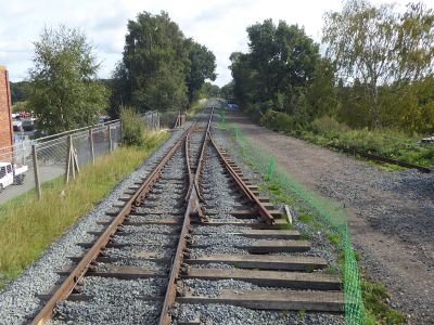
The new points at Foley Park. The Underbridge off Lisle Avenue is just beyond the points with Falling Sands Viaduct in the distance.
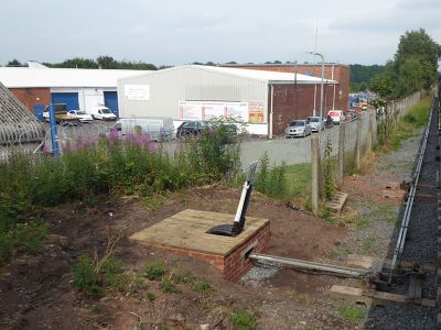
The ex-Kidderminster ground frame at Foley Park

