Difference between revisions of "Devil's Spittleful (Rifle Range) Bridge"
From SVR Wiki
(correct picture size) |
m (add links) |
||
| (4 intermediate revisions by the same user not shown) | |||
| Line 1: | Line 1: | ||
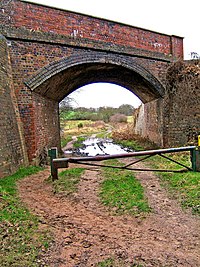
| − | [[File:Severn Valley Railway Bridge by Devils Spittleful Nature Reserve - geograph.org.uk - 664790.jpg|thumb|200px|right|Bridge viewed | + | [[File:Severn Valley Railway Bridge by Devils Spittleful Nature Reserve - geograph.org.uk - 664790.jpg|thumb|200px|right|Bridge viewed from the North]] |
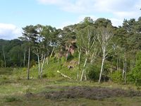
| − | Bridge 7 carries the railway over a bridleway on the Rifle Range Nature Reserve. | + | [[File:Devils_Spittleful_20150528.jpg |thumb|200px|right|The Devil's Spittleful]] |
| + | Bridge 7 carries the railway over a bridleway on the Rifle Range Nature Reserve, near the site of the former [[Rifle Range Halt]]. The Devil's Spittleful, after which the Reserve and Bridge are named, is a large sandstone outcrop on the heathland to the right of the line when travelling towards Bewdley. | ||
==See also== | ==See also== | ||
| + | [[Bewdley Tunnel | Towards Kidderminster]]<br> | ||
| + | [[List of infrastructure]]<br> | ||
| + | [[Bewdley Bypass Bridge | Towards Bridgnorth]] | ||
| − | [[ | + | |
| + | [[From The Window]] | ||
Revision as of 17:10, 25 November 2015
Bridge 7 carries the railway over a bridleway on the Rifle Range Nature Reserve, near the site of the former Rifle Range Halt. The Devil's Spittleful, after which the Reserve and Bridge are named, is a large sandstone outcrop on the heathland to the right of the line when travelling towards Bewdley.
See also
Towards Kidderminster
List of infrastructure
Towards Bridgnorth

