Difference between revisions of "Buildwas"
m (add map) |
m (Add PG Hindley photo) |
||
| Line 26: | Line 26: | ||
File:Buildwas-6128-Goods-1961-06-09.jpg|A goods train waits to depart for Much Wenlock in June 1961 ([[Sellick Collection]]) | File:Buildwas-6128-Goods-1961-06-09.jpg|A goods train waits to depart for Much Wenlock in June 1961 ([[Sellick Collection]]) | ||
File:Buildwas railway station 1935708 42d2f55f.jpg|Buildwas station and Ironbridge "A" power station ([[Sellick Collection]]) | File:Buildwas railway station 1935708 42d2f55f.jpg|Buildwas station and Ironbridge "A" power station ([[Sellick Collection]]) | ||
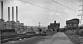
| − | + | File:PGH_BuildwasJn.jpg|Buildwas station building in 1962. The signalbox is visible at the far left of the frame. (PG Hindley) | |
</gallery> | </gallery> | ||
Revision as of 21:08, 23 November 2015

| Towards Hartlebury and Kidderminster | Towards Shrewsbury |
|---|---|
| Ironbridge (1½ miles) | Cressage (4 miles) |
Buildwas, officially Buildwas Junction, was situated 28½ miles from Hartlebury and 12¼ miles from Shrewsbury. It was an interchange station in open countryside with no passenger access other than by rail, and was built on two levels. The station building was of a similar design to that at Bewdley.

Approaching the station from the south, the single track Severn Valley Line was joined from the right by the double track line from Coalbrookdale, which crossed the river via the Albert Edward Bridge. In the short distance between the bridge and the station, the Much Wenlock line (the Much Wenlock and Severn Junction Railway before incorporation into the GWRGreat Western Railway) began to branch off to the left and climb, the single platform for this branch being on a higher level than the two platforms for the Severn Valley Line (at opening on 1 February 1862, Buildwas was the first station at which trains leaving and approaching Shrewsbury could cross).
A new power station came into use in 1932, requiring extensive additional sidings and a new signal box to handle the coal traffic. The station also handled limestone traffic from the quarries on Wenlock Edge.
West of Buildwas the Severn Valley line left the Severn Valley gorge and entered the flatter flood plain area leading towards Shrewsbury.
In the early 1960s a second power station, Ironbridge B, was in course of construction. The station closed along with the Severn Valley Line in 1963, and was demolished in 1964 to make way for a new coal handling plant for the power station.
Gallery
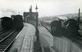
A busy scene at Buildwas. Two Severn Valley trains sit in the platforms on the right, whilst a service from Much Wenlock passes a goods train in June 1961 (Sellick Collection)
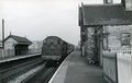
A Westbound Severn Valley service waits in the station in June 1961 (Sellick Collection)
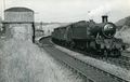
A goods train waits to depart for Much Wenlock in June 1961 (Sellick Collection)
Buildwas station and Ironbridge "A" power station (Sellick Collection)
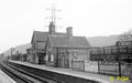
Buildwas station building in 1962. The signalbox is visible at the far left of the frame. (PG Hindley)


Sources
The Severn Valley Railway, John Marshall
Severn Valley Railway, A View from the Past, MA Vanns
See also
The Severn Valley Railway under GWR/BR ownership
Pre-1965 Map