File:OS Kidderminster Bottom Yard 1938.jpg
Summary
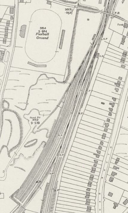
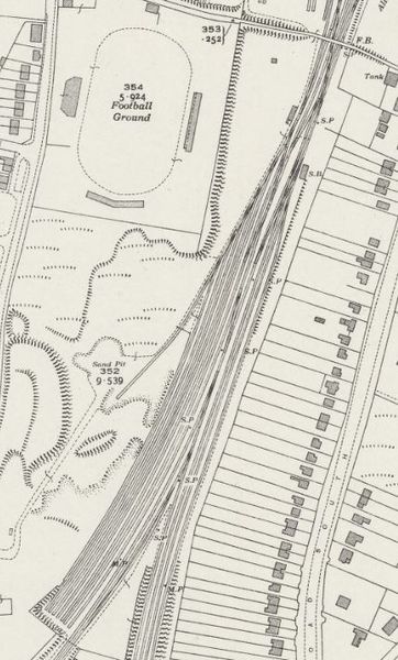
Extract from the OSOrdnance Survey 25in map Worcestershire XIV.3 (Kidderminster Borough; Stone) Revised: 1938 to 1939, Published: 1938, showing the area south of Kidderminster Footbridge ("the Wooden Bridge") at Kidderminster Station including the "bottom yard" of the goods yard.
The small building next to the lines leading into the sidings (level with the words "Football Ground") was the Shunters' Cabin. In 1943 the old Cabin was demolished and a new one built nearer to the Wooden Bridge (which is still present in the Diesel Depot). This allowed two sidings to be built for Wagon Repairs Limited. At the same time three more marshalling yard sidings were added at the south end of the yard, equally spaced with the seven shown on the map.
Licencing
This image is derived from an original Ordnance Survey Map held on the National Library of Scotland Map Images Website.
Reproduced with the permission of the National Library of Scotland under the terms of the Creative Commons Attribution-NonCommercial-ShareAlike (CC-BY-NC-SA) licence.
File history
Click on a date/time to view the file as it appeared at that time.
| Date/Time | Thumbnail | Dimensions | User | Comment | |
|---|---|---|---|---|---|
| current | 14:41, 18 May 2021 | | 429 × 711 (82 KB) | Robin (talk | contribs) | Extract from the OS 25in map Worcestershire XIV.3 (Kidderminster Borough; Stone) Revised: 1938 to 1939, Published: 1938, showing the area south of Kidderminster Footbridge ("the Wooden Bridge") at Kidderminster Station including the "bottom yard" o... |
- You cannot overwrite this file.
File usage
The following 2 pages link to this file: